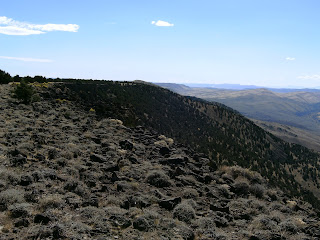
End of Leg # 10 - Looking across the Coleman Valley at our starting climb for leg #12. Got a really early start.

Looking back west a couple miles into Leg #12 after climbing out of the Coleman Valley up to a mile wide mesa.

Perfect conditions Saturday with high overcast, a light breeze, and about 60 degrees. Got up out of the valley well enough and across the first mesa of nothing but sparse junipers and lots of thin wheat and sage. The BLM plants a variety of hearty wheat for ranging animals to forage on that’s called thin wheat that, unfortunately sheds an unbelievable amount of seeds that like cotton socks. The chaf in our socks becomes pretty uncomfortable as the day wears on. We made pretty good time climbing a couple of juniper covered ridges with several small springs and a couple of small dribbling creeks. Had beautiful views to the north up Warner Valley and Hart Mtn. most of the day.
This is looking north into the Warner Lakes Valley, the notch in center frame, from the top of the first mesa. Hart Mtn is the prominent ridge to the right.

Still haven't got the camera working well. I think this was mile point 297.

A little more sunshine as we continue west through the rolling hills covered with Juniper.


Mile point 298 below.

Looking south into Nevada.

Looking north at the Warner Valley.

Looking south into Nevada.
Looking north at the Warner Valley.
Continuing west. 

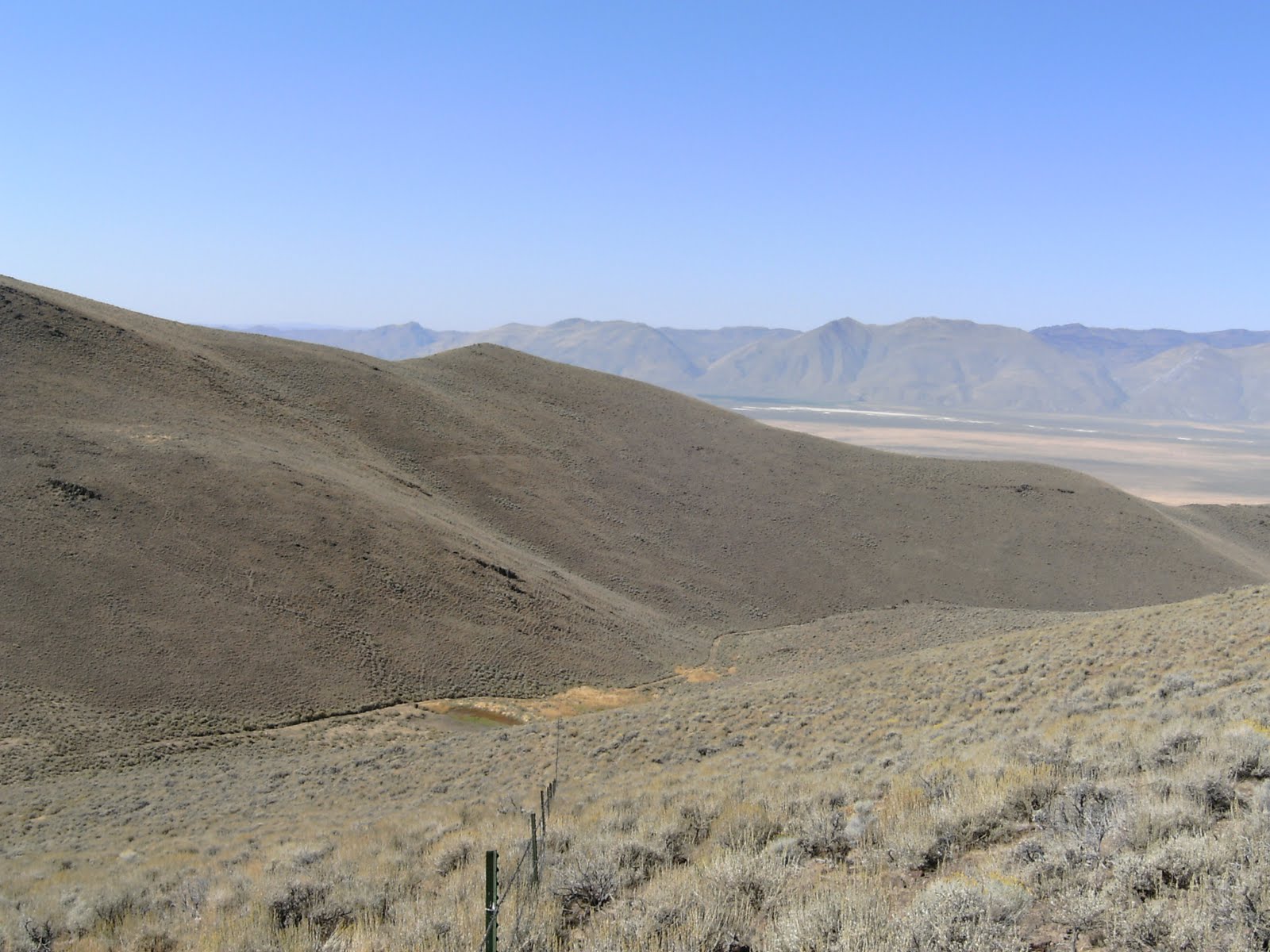
 We were above 6000 feet most of the day and then started loosing altitude as we crossed a 4-5 mile plane intersected by several creeks and canyons running from South to North. We came to a grassy spring area at the eastern edge of this plateau that took a little time to cross. We kept trying to find a narrow point to cross the marshy, grassed area as we, mistakenly, kept skirting downhill to the north. When crossing water features, even muddy streams across a path, it’s generally a good principal to always step, or go around on the uphill side. As we had neared the marshy spring area we had rousted a small coyote that kept in front of us for a mile or two. We caught sight of him/her several times moving west in front of us – no doubt aggravated by our presence. We saw several sage rats lying dead at the grassy spring and theorize the Coyote was catching them until we interrupted him. Continued on for a couple of miles on this westward slope and crossed a couple of small gullies. One was particularly beautiful with a small stream running through it out in the middle of the plateau below. Center frame is oriented due west.

 Found a developed spring at the base of the hill we were coming off. You can see a concrete wall sort of left of center below.
 Looking back east at the hill and gulley we came down from. The spring above is center frame.

 Interesting rock and juniper stumps before we clear the junipers and head out on the plateau.


Looking north across the canyon from the same overlook point.

Below is looking straight west from the overlook where we figured we'd go down to the creek at this corner, up the far side and scurt along the hillside along the north rim. The hill to the left will appear later in a rear picture - note it's location at this oxbow in the canyon.
 Dwane took the lead as we stepped off the top and down a few feet to a first ledge with brush and dirt on it as we were eye level with the rim. Things happened pretty quickly after he stopped abruptly, yelled “damn there’s a snake down here”, and then immediately said “oh, it’s a little one”, but then “there’s a bunch of them”. He was telling himself at this point, trying to calm his fears, that they were no big deal because they didn’t have rattles until he correctly assessed a second or two later that they were young rattlesnakes which don’t have rattles. It was at this point Dwane also first noticed the 4-5 footer eyeing him from a waste high perch on top of the sage brush about arms length away. He moved back past me pretty quickly while yelling they’re diamond backs and get a picture of the big one as it dropped out of the brush and slithered towards us. As he hopped back up to my level a couple of feet above the ledge the smaller snakes were all scrambling among our feet trying to get out of the way. We backed up to the top of the rim and took a few minutes to collect ourselves while emotionally changing our underwear.
One of our BLM developed springs along the stateline up in the hills. This one probably hasn't been serviced in a few years.
Another shot of Warner Valley to the north.
We were above 6000 feet most of the day and then started loosing altitude as we crossed a 4-5 mile plane intersected by several creeks and canyons running from South to North. We came to a grassy spring area at the eastern edge of this plateau that took a little time to cross. We kept trying to find a narrow point to cross the marshy, grassed area as we, mistakenly, kept skirting downhill to the north. When crossing water features, even muddy streams across a path, it’s generally a good principal to always step, or go around on the uphill side. As we had neared the marshy spring area we had rousted a small coyote that kept in front of us for a mile or two. We caught sight of him/her several times moving west in front of us – no doubt aggravated by our presence. We saw several sage rats lying dead at the grassy spring and theorize the Coyote was catching them until we interrupted him. Continued on for a couple of miles on this westward slope and crossed a couple of small gullies. One was particularly beautiful with a small stream running through it out in the middle of the plateau below. Center frame is oriented due west. Found a developed spring at the base of the hill we were coming off. You can see a concrete wall sort of left of center below.Looking back east at the hill and gulley we came down from. The spring above is center frame.Interesting rock and juniper stumps before we clear the junipers and head out on the plateau. The small stream we crossed in the middle of the plateau. . Continued on for a couple of miles on this westward slope and crossed a couple of small gullies. One was particularly beautiful with a small stream running through it. We took a late lunch break on the rim rock overlooking the small stream during which I caught Dwane stretching out on the rocks. When we saddled up we had a couple of miles of gentling sloping plateau remaining until hitting a large canyon as planned.
The state line runs through this larger canyon for perhaps 5 miles while it’s oriented east and west. Got to the rim rock overlooking the 600 to 700 foot deep canyon with a beautiful stream, 12 Mile Creek, running through it about 3 miles from our intersect and end point for the day.
The original plan was to drop down into the canyon, and follow the stream up hill to the intersecting road for the last couple of miles. Below is a shot looking south from the overlook as the canyon makes an oxbow swing off the state line. 
That plan would soon be changed as well. Did I mention that I had intentionally not told Dwane the name of the canyon? 12 Mile Creek runs through Rattlesnake Canyon. We took a brief break at a point overlooking the canyon where it has an oxbow to the south before aligning with the state line and continuing west. This point had a SW exposure overlooking the creek and we got a few pics as we plotted our descent. Didn’t look too bad as there was plenty of soil, grass and brush after we got below the first few feet of the rim rock and slope was steep, but it looked no worse than others we’d done.
The two state mile points along this segment were high on the canyon wall and we decided not to climb up and down to check them out. It was getting late in the day and we didn’t like the idea of straggling along the stream in the rocky and brushy canyon, so we came up with a plan B. We decided to go down into the canyon at this point to cross the creek and climb up to the north rim and juniper treed plateau. There was a jeep trail along the north rim that we could use to make our way back to near where we left the bikes. The shot below is looking back east into the canyon from the overlook point.

Looking north across the canyon from the same overlook point.

Below is looking straight west from the overlook where we figured we'd go down to the creek at this corner, up the far side and scurt along the hillside along the north rim. The hill to the left will appear later in a rear picture - note it's location at this oxbow in the canyon.
 Dwane took the lead as we stepped off the top and down a few feet to a first ledge with brush and dirt on it as we were eye level with the rim. Things happened pretty quickly after he stopped abruptly, yelled “damn there’s a snake down here”, and then immediately said “oh, it’s a little one”, but then “there’s a bunch of them”. He was telling himself at this point, trying to calm his fears, that they were no big deal because they didn’t have rattles until he correctly assessed a second or two later that they were young rattlesnakes which don’t have rattles. It was at this point Dwane also first noticed the 4-5 footer eyeing him from a waste high perch on top of the sage brush about arms length away. He moved back past me pretty quickly while yelling they’re diamond backs and get a picture of the big one as it dropped out of the brush and slithered towards us. As he hopped back up to my level a couple of feet above the ledge the smaller snakes were all scrambling among our feet trying to get out of the way. We backed up to the top of the rim and took a few minutes to collect ourselves while emotionally changing our underwear.
 It was apparent at that time that the last couple of hours were going to be interesting.
The picture below is the only one I was composed enough to take once back at the top of the rocks. If you look closely you'll see a foot long rattler center frame at the botom of the crack, at the edge of the rock. That's where we'd stepped down into their den.

Crossing down and up the canyon was no longer something we were going to consider, so we headed off around the oxbow to the south staying along the rim of Rattlesnake Canyon. I’d been assuring Dwane all day that the snakes wouldn’t be out because it was relatively cool. I now know that in the fall it usually takes 40 degree weather for quite a few days to get rattlesnakes to curl up for the winter and they get really aggressive during this time of year while trying to stock up on food for the coming winter. The plateau above the canyon was juniper and thin wheat without any roads/trails we could note as we trudged along. At the south end of the oxbow, perhaps a half mile out of the way to the south, we came to another canyon from the south. It also looked pretty intimidating with its small creek and bushy/rocky sides, so we continued along it for a half mile to the south until forced to “man up” and cross it to avoid another extra mile or two of walking. We had veered a mile to the south of the line by now and my GPS wasn’t of much help as my loaded TOPO maps don’t show much of the Nevada, now California at this point, side. We reached the main canyon wall perhaps still a mile and a half from our exit point, but could not tell what lay ahead of us on the south rim with daylight rapidly fading. Decision point. Rattlesnake Canyon was still 4-500 feet deep at this point, but we made the decision to cross it as there were jeep trails on the north rim that we knew would lead us in the coming dark back to our bikes, but we had no idea what we’d find continuing on the south rim. Our fear was we’d hit another canyon on the south intersect that would take us another couple miles out of the way and we were getting tired and our feet were not in good shape. We decided the terror of crossing the canyon would be less than stumbling along the south rim in the dark. We found a spot with a huge boulder stream running almost to the bottom of the canyon and a similar rocky path up the other side and started down. We figured the snakes would not be in these barren rocks and began hopping and climbing down into the canyon. Worked pretty well except for the terrifying 50 yards or so of getting through the creek side brush and back onto the large boulders. Didn’t see any snakes as we beat the ground with our walking poles, threw rocks ahead of us into the brush and made enough noise to wake the dead up and down the canyon.
 Looking across the canyon to the north after we'd clambored down the boulder stream and headed to the boulder hillside above.

Beautiful little stream and valley, if you don't mind being snake bait.

The shot below is from the north hillside looking back at the south slope we'd come down. Beautiful valley with the birch trees turning color and a few firs mixed in, but the light was fading.


Crossing down and up the canyon was no longer something we were going to consider, so we headed off around the oxbow to the south staying along the rim of Rattlesnake Canyon. I’d been assuring Dwane all day that the snakes wouldn’t be out because it was relatively cool. I now know that in the fall it usually takes 40 degree weather for quite a few days to get rattlesnakes to curl up for the winter and they get really aggressive during this time of year while trying to stock up on food for the coming winter. The plateau above the canyon was juniper and thin wheat without any roads/trails we could note as we trudged along. At the south end of the oxbow, perhaps a half mile out of the way to the south, we came to another canyon from the south. It also looked pretty intimidating with its small creek and bushy/rocky sides, so we continued along it for a half mile to the south until forced to “man up” and cross it to avoid another extra mile or two of walking. We had veered a mile to the south of the line by now and my GPS wasn’t of much help as my loaded TOPO maps don’t show much of the Nevada, now California at this point, side. We reached the main canyon wall perhaps still a mile and a half from our exit point, but could not tell what lay ahead of us on the south rim with daylight rapidly fading. Decision point. Rattlesnake Canyon was still 4-500 feet deep at this point, but we made the decision to cross it as there were jeep trails on the north rim that we knew would lead us in the coming dark back to our bikes, but we had no idea what we’d find continuing on the south rim. Our fear was we’d hit another canyon on the south intersect that would take us another couple miles out of the way and we were getting tired and our feet were not in good shape. We decided the terror of crossing the canyon would be less than stumbling along the south rim in the dark. We found a spot with a huge boulder stream running almost to the bottom of the canyon and a similar rocky path up the other side and started down. We figured the snakes would not be in these barren rocks and began hopping and climbing down into the canyon. Worked pretty well except for the terrifying 50 yards or so of getting through the creek side brush and back onto the large boulders. Didn’t see any snakes as we beat the ground with our walking poles, threw rocks ahead of us into the brush and made enough noise to wake the dead up and down the canyon.
 Looking across the canyon to the north after we'd clambored down the boulder stream and headed to the boulder hillside above.
Beautiful little stream and valley, if you don't mind being snake bait.

The shot below is from the north hillside looking back at the south slope we'd come down. Beautiful valley with the birch trees turning color and a few firs mixed in, but the light was fading.

The view below is looking due east back to where we'd initially intesected the canyon. You can see the west side of the hill (center-right frame) that was across the canyon from the overlook where we found the snakes and were going to cross.

Looking back across to the south where we eventually crossed as daylight was starting to fade.
 We clambored up the north rim and picked up the road bout a quarter mile through the juniper and rocky plateau as dark set in. It was about a mile and ¾ to walk on up the road to the main road and back south to our mini-bikes in the dark. Found the bikes, stumbled around a little in the dark, but got headed back down the road in fairly short order. We road perhaps 8 miles on the gravel road, another 8 on paved county road, and then another 8 or so back up the Coleman Valley to where we’d left the truck in the dark. Saw the remains of at least 3 rattlesnakes on the road in the dark and I almost hit a damn deer despite only going the 21-22 mph we can make on the bikes. Had stew that night as we decided we were done for the weekend. The next leg entails at least 2-3 miles westward up the remainder of Rattlesnake Canyon. I doubt we’ll get interested until there’s snow on the ground and we’ve decided not to do it alone anymore, so we’ll have to get a support vehicle for future trips.
Caught the picture below the next morning after stopping in Adel to have some breakfast and hitting the road back home. We were about to pull out from Adel when we noticed an elderly lady cautiously crossing street right in front of us to get a picture of the wood sign denoting the village of Adel. I suggested to Dwane he offer to take her picture for her with her in the frame in front of the sign. He hopped out and did so and we had a 2 minute conversation with the delightful women in her 70's traveling alone. She'd just come into town with her VW Vanagon after enduring an hour and a half following a flock of sheep being herded down the road. She was treking across America looking at places the struck and interest from the names on the map. I'd ove the freedom of being able to do that when I'm that age if I find myself alone.
This is the beautiful view from within Deep Canyon of the turning leaves maybe 10 miles West of Adel along Hwy 140.


 Headed down into the first canyon we came upon one of the older milepoints.
