Sunday, March 28, 2010

Denio - 5th and 6th Legs


After making 5-6 miles from east of Denio on Day 5 (Directly above), we set up to knock out some mileage to the west of Denio on Day 6. Figured on doing some of the flat table top desert from about 12 miles to 25 miles west of Denio, but ended up further west where Hwy 140 crosses the line. We dropped the truck near the highway and headed east on the bikes via some desert roads and a few miles along the fenceline. Pretty easy walking along a fence line the whole way back with just a couple of small canyons and plateaus to cross. Saw some more antelopes. We'll have another 15 mile segment to the east we could have done the next day, but the weather closed in and we had a slow leak in a tire when we got back to Denio for the evening. Rowdy bar (Above left) with all the locals yukking it up over the idiot "Valley Boys" walking across their territory. We aired up the tire after dinner and headed to Fields since they have the ability to break down and repair tires. Slept in their parking area and had breakfast at the Fields Cafe. Young former Marine/disabled vet made us breakfast at the cafe and directed us to the tire shed to work on our tire. Ended up being able to get it off and plug the leak without having to break the tire down. Day was shot and weather was turning bad, spitting snow, so we decided to do some exploring and check the forecast for the next day. I took Dwane to see the Borax Hot Springs a few miles out of Fields in the desert valley floor. I've been there many times, but he hadn't seen this site where Borax was harvested and then transported via wagon around the turn of the century for a couple of years to Winemmucca and the railroad. Much of the earthworks still exist where they'd drain water from one of two 10-20 acre warm lakes (Top picture), let the water evaporate, rake up the borax and dry it under large open fires before shipping. There is a fault line about a 1/4 mile long extending north from the shallow lakes where small springs boil up through the desert floor ranging from boiling (2d picture above) to luke warm water. We headed back towards Denio (See the yard art "chopper" pic) around noon to check the weather forecast while eating some lunch. Bad news - snow and rain Friday with only Sat expected to be clear. The Cafe let me plug in to the web to confirm and we decided our trip was about over. We'd met a colorful local the day before who owns an Opal mine west of town, so we decided we'd drop in on him on our way back home that afternoon. We hit another hot spring, Bog Hot (3rd Pic above), on the way and stopped by to tour his "digs" on the Sheldon Wildlife Refuge. Headed on into Lakeview, grabbed a sandwich and headed west to Creswell, arriving just after midnight.


We've covered the first 50+ miles west from three corners to the base of the Trout Mtns, another 6 miles of the valley floor straddling Denio, and about 12 miles ending at Hwy 140 and the stateline - pushing 70 miles total. Kind of weak as we'd hoped to have 100 miles completed by the end of this last week and we're not sure when we'll get another shot at some miles.

Thursday, March 25, 2010

McDermitt Cr Canyon - 4th Leg from Hell


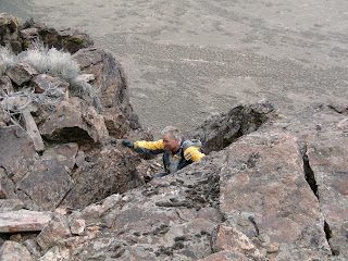
Well, these are the days that try men's souls took on new meaning for us. We'd planned to pickup west of McDermitt and get to the mountain foothills near the Zimmerman Ranch in one day. Saying we under estimated the terrain difficulty would give us some credit for a little intelligence, unfortunately, we lacked any intelligence on this, perhaps the most beautiful leg to date. We struggled. Headed east from the pickup late morning after dropping off the bikes west of the Zimmerman spread and driving back down the hill and out through the sage to intersect the state line where we'd left off. Got a late start as one of the bikes had a small mechanical problem we quietly fixed inside our McDermitt motel room. Anyway, the state milepoints were pretty much where they were supposed to be as we headed west across a plateau for the first couple of miles. We then dropped down into McDermitt Creek canyon and up the other side at an oblique which forced us to start crossing up and down through the side canyons until we bailed out by climbing far enough up the 6000 ft ridgeline to avoid going up and down the last couple of cross canyons. BEAUTIFUL creek and canyon, views of the mountains, etc. Pictures posted. We started down off the ridgeline to drop into the canyon with a nice 2 miles of walking across the Zimmerman valley ahead of us before the last couple up to the bikes. We ran out of daylight about the point we crossed the creek for the last time and hit the pastures/meadows. Walked on in the dark illuminated by a quarter moon for an hour and hit the Zimmermans place about 9PM with it about 20 degrees. We stopped and asked for a little water before trudging on to the bikes in the dark for another couple of miles and thank God they offered to run us up to our end point. Mr Zimmerman drove us up the valley through his son's (Arnie Zimmerman) ranch to our bikes and followed us back down the hill. Ever rode a motorcycle in 20 degree weather down hill on dirt roads??? Even at 20mph we had to stop 2-3 times in the ten miles to let the blood return to our hands and legs. Drove the bikes in the dark out through the sage and found the truck fairly straight away - surprise. We loaded up in the dark and made it back down to McDermitt about midnight. Thankfully the Casino is open 24 hours and even though the restaurant was closed the nice folks on duty made us some great roast beef sandwiches as we continued to thaw out. Our plan was to relocate that night to the Denio valley to the west and decided what the hell - we might as well head that way. Made it half way there to the Willow Cr Hot Spring (BLM) and pulled the bikes out so we could crawl in our bags and get some rest after soaking in the hot spring under the stars for a half hour or so. By then it was about 2 AM. We got up late, late morning, loaded back up, and met our other brother Dave in Denio Jct for lunch. Dave and his wife were headed down to Yuma for a spring break and had swung over east on the off chance they'd catch us. Worked out that way. You see you have cell service all over the valley east of Steens because there's a tower on top of that 10,000 foot mtn. We had just gotten out of the hot spring that morning and were getting reloaded when my cell phone rang and suprise - it's Dave and Linda. Anway, had a good lunch with the locals at Denio as we plotted our next day's debacle. Decided we still had enough daylight that we might as well pick off some valley floor desert miles before dark. We found a power pole just west of Denio to chain the bikes to and headed back east across the desert valley floor in the truck to a start point at the foothills. This time we hit it about right and trudged across the valley through tumble weeds, sage brush and prickly weeds just hitting Denio about dark. Had enough time to jump on the bikes, a little warmer that night but still approaching 35 degrees, and head back out to find the truck in the dark. Next days plan was to pick up some miles in the desert flats west of town.

Sunday, March 21, 2010

McDermitt - 3rd Leg


We made it down Friday evening about dark, had dinner at the McDermitt Casino (Some pretty good fish and chips and friendly service), and headed out to the point we'd started from about 20 miles west of the state line. Got there about 9:00, found a spot for the evening a mile or two from our attack finish point, and camped overnight. Next morning we were able to drive a mile or so north to the planned finish point for the day through a foot of snow because it had frozen up overnight and we were able to drive across the top few inches of the snow. The point we picked was actually a half mile south of the fence line we wanted. Unloaded our two mini-bikes and headed east to the three corners start point. Interesting three sided monument out in the middle of nowhere. This point was established back before 18880. Most survey markers are from 1911-1922. We left the bikes and headed west. Pretty level and desert terrain for the first 10 miles or so. We started climbing a little and began crossing some really pretty canyons and small streams. Beautiful country overall and the weather was great. Sunny, but cool. Saw several herds of Antelope sprinting across our path or away from us. End of the day wasn't so fun. Last three miles or so were across snow fields of a few inches to a foot or so and soggy desert bottoms. Got muddy and wet as we slogged along expending about 3 times the effort of climbing small hills. Made it to the truck about 7PM intending to drive back to three corners and get the bikes. We made it about 2-300 yards and buried the truck in the snow. Just too soft at above freezing temps. We shoveled, jacked, hauled rocks, etc for an hour so until conceding we were not getting out easily until it froze up again. Camped for the night and got an early start at it in the morning. Used my four 2X6 planks for my bunk to put under the tires after we jacked it up clear of the deep snow. Had to do it a couple of times to get some momentum going forward until we got down the road into shallower snow. Drove the 20 miles on out to the corner and picked up the bikes and headed back into town for lunch. After lunch we picked up and headed west of McDermitt to the point we'd left off the first weekend. Since we'd gotten such a late start we planned on only 4-5 miles continuing west and thought we'd check out the next days end point. Drove all the way 2o miles west of McDermitt, met a charming couple at the end of the road at their farm near where we figure we'll have to wait a couple of months as the route climbs to nearly 8,000 feet and there's tons of snow up there. The Zimmermans have been married some 67 years and their son has the other ranch further up the valley. Nice couple - we stopped by to explain we'd be leaving a rig near their ranch and driving across it up into the BLM lands at our end point. They were all friendly and helpful with directions, suggested we camp at their place and leave our rig there - wish we had. Anyway, we had a few hours of daylight left so we drove back towards town and found a beautiful canyon that intersects the line about 4 miles west of our attack point. Left the truck, jumped on our 196cc "Hogs" and headed west to the start point. The bikes make 23 mph, 24 down hill, and they don't pull up very steep hills. We struggeled to get up jeep trail to above the cliffs we'd left off on back in January, but made it by walking beside the bike and its spinning tire while climbing the hill. We headed from milepoint 195 westward back to the truck. Beautiful day. Made it to the truck with enough daylight to be able to drive back towards town and crawl up the rocky hill to retrieve the bikes. Spending tonight in the Hotel. Figured after two nights - three days we were getting gamy. Tomorrow we complete the last leg still possible at these altititudes below about 6500 feet out to the Zimmermans and then we'll relocate over to Denio.

Wednesday, March 17, 2010

PART TWO

We'll we're headed down to McDermitt this Friday and taking a week to get as many miles as we can under our belts as the weather seems to be clearing most of this week. We expect to hike the first segment from the state corner 25 miles westward and then another 15-20 miles west from where we left off done this weekend. The segment between McDermitt and Denio will be tough logistically and physically and we're likely to skip the middle 15 miles until the snow melts as it includes a ridge of nearly 8,000 feet in altitude. We're taking my larger camper shell and two off road type mini-bikes I picked up a couple of weeks ago. We'll likely sleep in the camper and use the mini-bikes to shuttle from start to finish or vice versa. We actually figure we'll use the bikes to get to the start point because we'd rather ride in my truck in the dark after walking 15-20 miles than ride the mini-bike back to the day's starting point. We're hoping to get at least a hundred miles done in the coming week and get close to Goose Lake, but we haven't recon'd the area west of Denio so there's no telling how much snow is in that country. We'll have to leap frog the hundred miles or so around to the Denio valley and work from there probably on Monday. Wish us luck - we'll be posting pictures as we can.