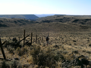

 First 3-4 miles was expected to be pretty flat, with a gentle elevation gain until hitting the Daugherty Slide and the basin below for about a 1000’ drop. We hustled right along through the low sage and high desert across a few small gullies rimmed by rock and with Mtn Mohagany patches overlooking. You can see Dwane at our first break on the rimrock ledge in the Myrtle. Was a little warm, but we had a nice breeze and were pretty greased up with sunblock – so it went fine.
Below, if you look close you'll see three different monuments, probably all supposedly marking the same surveyed point on the ground.

This is what the surveyed mile points look like - most of the ones in this stretch of the border are from a 1939 survey. They are pretty close to the GPS stateline I have loaded.

A couple miles in looking back east from the Mohagany covered ridge.


Mile point 272.

Looking west over the last 3-4 miles before the Stateline Cyn.
Saw a few antelope and we spooked a large mountain lion that lept over the fence and ran across our path about a hundred yards ahead of us. Couldn’t get my camera out quick enough to catch it before it disappeared into a 3-4 acre swath of sage brush and grass. Dave had a hunting tag for cougar with him, but we conferred on the radio and decided we’d rather not have to figure out what to do with a large cat for the next 3 days anyway. Besides, none of us really wanted to go into the brushy area and roust the animal. They are apparently pretty common around the high desert as the locals were disappointed later that evening when conveying the story at the bar in Denio that we didn’t get a shot at it. Anyway, labored on along the fence for a couple more hours and came to the Stateline Canyon.

Dropping down into Stateline Cyn - highway runs parallel and about 3/4 mile to the right, or north and drops over Daugherty Slide.

Most of the mile point markers we came upon were fairly accurate per our GPS readings, so we elected to pass on climbing a rock cliff to try and find the one falling in the middle of the last 2 mile segment on the side of the canyon. We scrambled down into the canyon and proceeded to be-bop right along down the dry creek bed through the rocks and brush down to the valley floor. It drops the 1000’ in about a mile. Saw a few mule deer watching us curiously from up on the canyon walls, but didn’t see any other wildlife other than squirrels and rabbits. With our water gone, butts dragging, and sunlight fading we broke out into the valley floor and scrambled to get a hold of Dave on the radio as the sun went down.


Headed on to Denio to claim the rooms we’d booked at the Denio Jct bar, store, restaurant, motel, rv park and gas station. Had a couple of entertaining drinks with the locals, though we were too late for dinner. I always size up these local watering holes when we first walk in. I like to spring for a round of drinks for everyone to break the ice. Never can tell when that same drunk, toothless SOB harassing you for being a city slicker government employee all night will be the one to save your ass when you break down out in these parts miles from anything and anyone. Anyway, a local had a bad break while hunting a week earlier and had a reward posted for some help. Seems he had hit the biggest buck deer he’d ever seen with an arrow, but couldn’t track the animal and lost it in the darkness. Knowing that it was a trophy animal he had posted a $2000 reward for anyone who found and the animal and located the rack for him. He had the GPS coordinates listed for the point where he had last seen it and I confirmed on our maps to find the spot was within a hundred yards of our remaining route on a segment over the mtns east of Denio. So we did some conferring and even though Dwane and I weren’t keen on talking any of the really high mtns, we figured $2000 is $2000, so what the hell.


Mile point 272.

Looking west over the last 3-4 miles before the Stateline Cyn.
Saw a few antelope and we spooked a large mountain lion that lept over the fence and ran across our path about a hundred yards ahead of us. Couldn’t get my camera out quick enough to catch it before it disappeared into a 3-4 acre swath of sage brush and grass. Dave had a hunting tag for cougar with him, but we conferred on the radio and decided we’d rather not have to figure out what to do with a large cat for the next 3 days anyway. Besides, none of us really wanted to go into the brushy area and roust the animal. They are apparently pretty common around the high desert as the locals were disappointed later that evening when conveying the story at the bar in Denio that we didn’t get a shot at it. Anyway, labored on along the fence for a couple more hours and came to the Stateline Canyon.

Dropping down into Stateline Cyn - highway runs parallel and about 3/4 mile to the right, or north and drops over Daugherty Slide.

Most of the mile point markers we came upon were fairly accurate per our GPS readings, so we elected to pass on climbing a rock cliff to try and find the one falling in the middle of the last 2 mile segment on the side of the canyon. We scrambled down into the canyon and proceeded to be-bop right along down the dry creek bed through the rocks and brush down to the valley floor. It drops the 1000’ in about a mile. Saw a few mule deer watching us curiously from up on the canyon walls, but didn’t see any other wildlife other than squirrels and rabbits. With our water gone, butts dragging, and sunlight fading we broke out into the valley floor and scrambled to get a hold of Dave on the radio as the sun went down.


Timing wise, it was great and we covered a little over 6 miles. However, the heat took its toll on us and portended what was to come. We loaded up in Dave’s FJ in the middle of the akali dessert valley and he had some cool Mikes Lemonade for us to down with about a gallon of water each. Temps were nearing 90.
Headed on to Denio to claim the rooms we’d booked at the Denio Jct bar, store, restaurant, motel, rv park and gas station. Had a couple of entertaining drinks with the locals, though we were too late for dinner. I always size up these local watering holes when we first walk in. I like to spring for a round of drinks for everyone to break the ice. Never can tell when that same drunk, toothless SOB harassing you for being a city slicker government employee all night will be the one to save your ass when you break down out in these parts miles from anything and anyone. Anyway, a local had a bad break while hunting a week earlier and had a reward posted for some help. Seems he had hit the biggest buck deer he’d ever seen with an arrow, but couldn’t track the animal and lost it in the darkness. Knowing that it was a trophy animal he had posted a $2000 reward for anyone who found and the animal and located the rack for him. He had the GPS coordinates listed for the point where he had last seen it and I confirmed on our maps to find the spot was within a hundred yards of our remaining route on a segment over the mtns east of Denio. So we did some conferring and even though Dwane and I weren’t keen on talking any of the really high mtns, we figured $2000 is $2000, so what the hell.

No comments:
Post a Comment