Thursday, January 5, 2012

Leg 19: Renner Lake valley

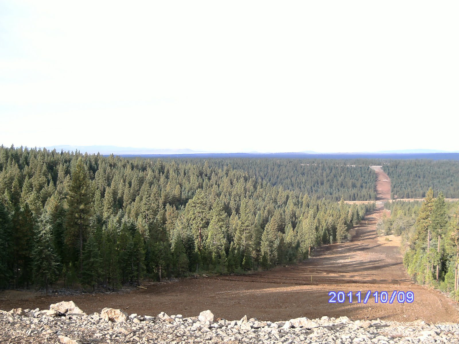
I was having fits with the GPS as we were driving that night and apparently left the darn thing on overnight. By morning the GPS had become a useless “brick” and would not initialize or load up. We were close to the pipeline right of way so we headed generally east and up hill crossing back and forth across the right of way till we got to the high ground we took these shots from. We could see the Malin hills we’ve yet to cross and even Mt Shasta to the SW. Beautiful forest and country side again. Looks like prime elk habitat and we found our way south to intersect the line and Corral Creek road at about 34 after some fun exploration. Found the bikes and prepared to leave the truck intending to ride the bikes east and down into the Renner Lake valley from its east end and then walk back to the truck. Didn’t have the GPS for help, but I had some Topo map prints and I could remember where the mile points were in the valley, so we felt confident. Heh heh!

These pics are looking back west from above where we slept. At this point the pipeline runs about mile north of the state line and this is from the hill west of Renner Lake.



Here's where we unlodaded near MP 32 to take the bikes back east down into Renner Lake Valley.

Leg 19 - The Incident.

Wish I’d had the camera rolling as we prepped the bikes – I know I’d be a millionaire at Dwane‘s expense! The bikes seemed a little hard to get started and I discovered a new idiosyncrasy about them. Seems that if we choke them too much they don’t really flood, they end up with an extra load of fuel in the carb. Once it finally starts the engine will race like it’s full throttle until the excess fuel is consumed. I got my fired up and fortunately got a quick grip on the brake as it started to take off. Warmed it up for a minute and then shut it down to advise Dwane on getting his running when about the funniest damn thing so far happened. I was forming the words in my mouth to caution Dwane about starting his bike while standing beside it instead of setting on it and in better control when his engine came to life. I think I got “I wouldn’t start it” out just as his bike took off at full throttle with Dwane hanging on to one side of the handle bar. I started yelling “let it go” as it ran up the side of my pickup with him dragging along with it like a rag doll still instinctively trying to control it with one hand as the bike revved for perhaps 4-5 seconds that seemed like an afternoon. If I hadn’t been suddenly focusing on what materials I had to fashion splints out of I would have been laughing my ass off as he danced a couple of dosie does with the bike until being whipped sawed to the ground as the bike finally fell over and died. I honestly didn’t think he was going to get up for a moment. After a couple of minutes Dwane assessed that he probably hadn’t broken anything even though the trauma made him sick to his stomach as he lay there with initial shock setting in.

We took a break.


After Dwane was on his feet again and properly instructed on how not to start these bikes we saddled up and headed west. Had a great ride and after a half hour and perhaps 10 miles running along smooth dirt roads we found a steep forest road that took us down in to the Renner Lake valley.

Without the benefit of the GPS it took a while to get oriented on the valley floor. Beautiful little piece of heaven, that valley. The farm house is at the west end of the lake on a mini rim rock overlooking Renner Lake. Can’t imagine owning that kind of spread.

This is a lake south and a little east of Renner in ths same valley.
The left half of the far ridge line is west of Renner, which is just out of sight, and is the east slope of the hill from which the previous pipeline pics are taken.

We set out along the fence line from the east end of the valley and found 28 after taking a while to soak up the view.


We could occasionally see someone at the house in the distance as we worked our way west along the south end of the lake. Found some unusual rock formations as we approached the shallow SE finger of Renner Lake.


The shallow lake was very low, but still didn’t reveal mp 29 where I remembered it on the map. A mile further west and we were near the house, but didn’t find 30 which should have been right there. Our focus was to finding mp 31 just below the 100 foot cliffs that ring the valley along its west and south rims. We gambled we’d be able to find a way back up the cliffs and the remaining mile across the high plateau to the truck. No such luck. As we started up the forested slope to the west it became increasingly difficult navigating thru the thick Manzanita underbrush in the pine and fir forest. Without the GPS functioning we wondered back and forth thru the brush, up and down the slope trying to line up visually with the fence line and mile point 28 some 3 miles to the east and barely visible. This pic is looking back east from below the rim rock cliff across Renner Lake - Goose Lake is in the far valley and MP 28 is at the far brown field on the other side of the lake. You can see the heavy brush in the forground we were struggling thru.
Sadly, after an hour or so and determining the cliffs appeared to be too big of a challenge we decide the way we’d came was the better choice even late in the day. We trudged back eastward across the valley to the bikes and saddled up.

We headed up the road we used to get there, but there were some steep sections to navigate. I was concerned that my bike wouldn’t pull my fat 275 lbs up the hill, but found that with a full throttle and good run up I could make it up the several hundred yard stretches on the steep inclines.

Even though evening was coming on, we stopped to take in the late afternoon sun at one of the many meadows along the beautiful forest road. Made it back to the truck, loaded up, but decided to hike east to the rim rock cliff and see if we could find the line. We did as it was getting dark finding a section marker and sign at the top of the cliff overlooking the manzanita and forest we'd stalled in below several hours earlier. Got dark on us as we wondered a little in the forest to re-find our truck, but we did so without too much delay. We saddled up and headed back towards K Falls for a late dinner. At dinner over our meat loafs, a tradition on our road trips, we assessed our situation. We’d talked about leapfrogging to the west of the Klamath River and getting a segment done in the morning, but without the GPS and a good map recon of that area we figured we were asking for more trouble trying to navigate and find the mile points.

We decided just to get in the rig and head home. We headed out of K Falls at about 10:00, turning back to town because the discount gas station on the north end wasn’t open as hoped, and we rolled into Creswell about 1 in the morning.

Still haven’t figured out what’s up with my Magellan. Won’t initiate or talk to my lap top with or without the card in it. The factory guys are absolutely no help. Found several hints on line including the secret three finger reset of Select, Page and Power buttons simultaneously, but to no avail. Finally was told by the manufacturer to send it in for a small discount on a newer model. Damn thing is only a year and a half old! I think I’m switching to Garmin.

We tried to pull off an early Nov outing, but work forced a canceled 4 day outing.

Leg 18: West of Renner Lake

Leg 18.
We stashed the bikes again in a meadow on a hillside bench at about 32 and humped back to the truck hitting the mile points pretty much only 20-30 yards from the dirt road. Made good time since we were on the road most of the way.


It was late afternoon when we got back to the truck and loaded up to head back to the bikes. Figured we would recon the road on past 32 to see where it came out at Goose Lake. As we meandered down Corral Creek road eastward it passed thru beautiful country side of open meadows and large pine forests a mile or two south of the state line which bisects that lower half of Renner Lake valley.

We continued on down the road to head towards Lakeview for some dinner. We still had a little daylight remaining when we hit the graveled county road that runs the length of Goose Lake along its west side. This country is so deceptive for distance and we slugged on into town picking up the pavement as we re-crossed the state line into Oregon and had a great dinner, as always, at The Dinner Bell on the south end of the main drag in Lakeview. They have a truly extraordinary chef and we’re always surprised at what their specials are. It was likely 7:30 as we headed back out of town in the dark to find an approach into the Renner Lake valley from the Oregon side. So much for those plans. There’s a gated private road that leads right up from the Goose Lake and the County road fairly close to the state line, but we endeavored to find a route down into the valley from the Forest roads along the hills to the north. Plan was to sleep in the valley near the lake and head back to the bikes on foot in the morning. No such luck. We tried several roads that obviously went south downhill into the valley, but they were all gated and a couple posed a pretty good challenge to our 4WD. Rains a few days earlier and the lack of gravel meant soft and rutty surface up steep hills. We ended up giving up on finding a way thru in the dark and found a place probably at about 34/35 north of the state line probably a mile to sleep for the night. Nice little grove of pines near the pipeline. Cool night again, but our camper is pretty comfortable. I sleep across the bed on one bunk and Dwane sleeps on the truck bed floor lengthwise. We can stand in the tradesman style canopy and have overhead bunk for our gear.

Leg 17: East of Langell Valley

Leg 17.
In the morning it was brisk to say the least, but beautiful. Had to be in the 20’s at best with a heavy frost everywhere.


We ate a bagel and a couple more food bars and got an early start headed back to the bikes at 45, hopefully where we left them the day before.

This was one of the absolutely most enjoyable legs of the trip to date. Beautiful pine forest, fairly level terrain, intermittent small stream crossings – we were having a ball.

We passed thru a couple of long ago abandoned hunting camps and an area that had been cleared several years ago thru a prescribed burn of the lower brush and fuel on the forest floor.

Found this birds nest - I think from a Jay.


Jumped one deer, a large mule deer doe that I saw take off from about 50 yards in front of us, but not much other wildlife. We crossed a couple of hundred hard wide pastures that were flooded which was a pain as we couldn’t avoid getting our feet wet. We only saw one ranch a half mile or more down one of these pasture meadows to the south.

Caught the pic you see of the tangled limbs of a tree we chose to take a break under late in the morning.


Most of the line was close to our map and fenced, although in a couple of places there was a current fence and at least two other ancient parallel fence lines 20 to 30 yards north or south of the current state line.


A couple of the large meadows had significant boulder fields of lava rock which were not easy to traverse with any speed. We always wonder what it must have been like crossing such areas as a pioneer in a wagon.


Made pretty good time taking care to skirt one hunting camp while making plenty of noise about the halfway point to 45 and surprise – the bikes were still there.


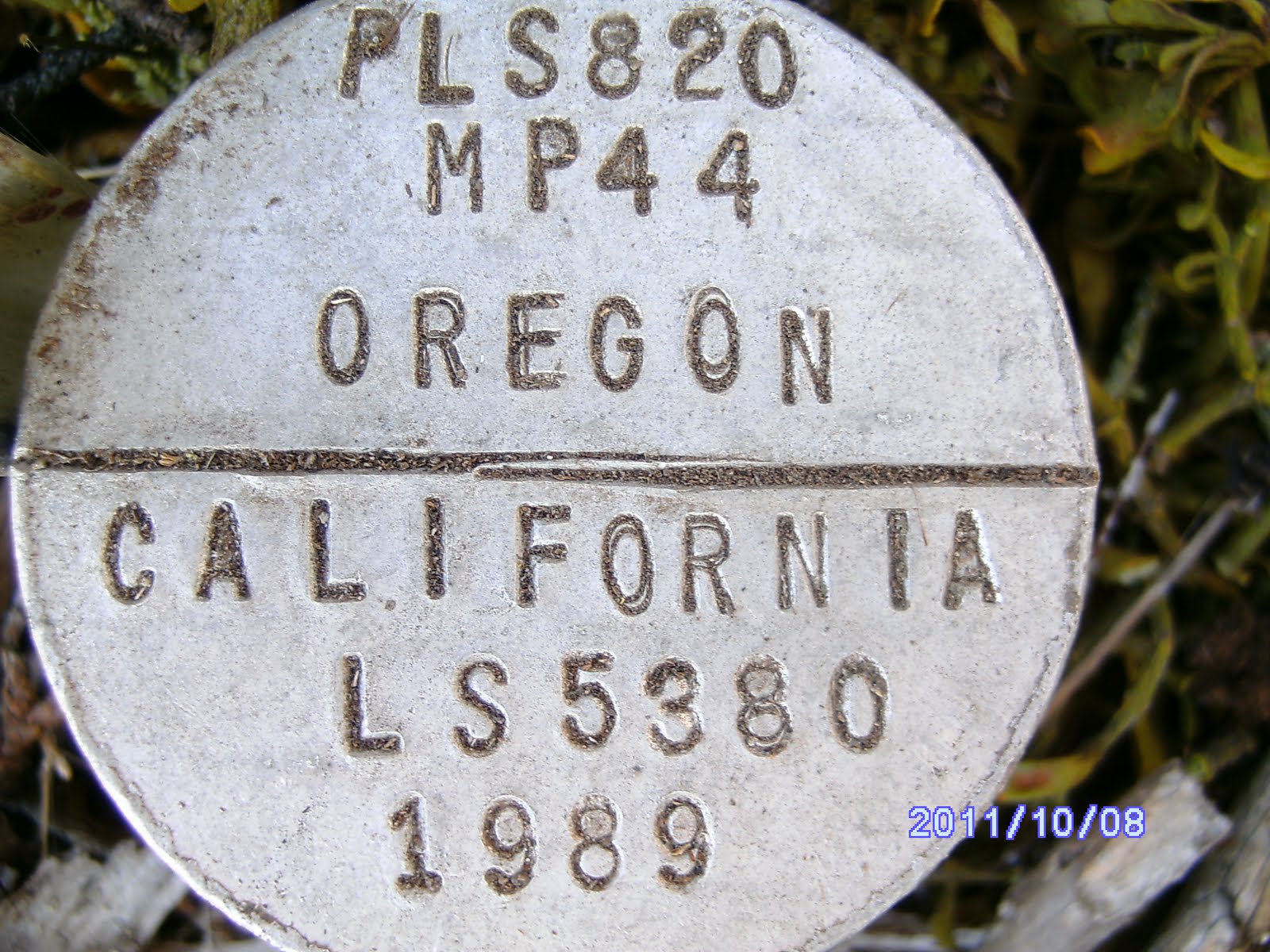
My lucky number mile point 44 had the biggest rats nest on it.
We usually cleaned off the debris so we could get a picture of the monument.


The ride back to the truck was great as it had warmed up and the flat, well packed cinder and dirt roads made for some fun full throttle stretches. Never did see any hunters while hiking, but we passed a couple of guys trolling along the road with their quads that were clearly surprised to see us overtake them. Drove back to the truck in about 30 minutes, took a quick break and then headed on to the east with the bikes along Corral Creek road which parallels the state line before dropping south and then into the Goose Lake basin. We ran on down to about 32 where the road leaves the state line and wanders more to the south skirting the cliffs bordering the Renner Lake valley.

Legs 16: Oct 2011 Langell Valley

Well, I suppose 23 plus miles over 2 and half days isn’t bad. Although we hoped for more, my Magellan 500 GPS gave up the ghost sometime late Saturday night and I still haven’t gotten it to work. Finally had it tuneed in and working fine Friday and all day Sat, but I left it on overnight and Sunday it was locked up. Removed the card, batteries etc but wouldn’t “boot up” again. Tried it at home and looks like the thing’s scrambled and I lost the data from Fri and Sat.

Leg 16. Dwane and I headed down early Friday, not as early as we’d liked, but it turned out OK. Dwane came down Thursday and we attended the Oregon – Cal football game that evening. Did I mention the Ducks thrashed the Bears! I had loaded up everything the previous weekend, so the next morning we got an early stop, topped off with fuel and munchies and headed towards Klamath Falls intending to fill in some of the gap between Lakeview (Goose Lake) and Malin. We got a few supplies in town after the 3 hour drive down and then headed east out into the Langell Valley area along the newly operational natural gas pipeline. Managed to make one wrong turn and headed back towards Malin instead of SE as desired, but after a quick turnaround we only wasted a about 10 miles of out of direction driving. Would have liked to be able to blame Dwane, but alas, I was driving and not paying attention to the intersections. The pipeline carries natural gas from Wyoming all the way to Malin where it plugs into the major west coast distribution system. Those cowboys will be able to pass their gas on to California now! We’d hiked a few segments back along their right of way and it was neat to see how they’d finished up the 100 yard swath they cut through the southern width of the state. The BLM made them sort rocks, save woody debris and whole trees, and then re-landscape the whole right of way with the rocks and down trees.

Here's a milepoint burried in a squirrel/rat nest. We found several like this where they had mounds of rock covered with woody debris.


Most of the country was wooded with open areas such as this and we walked along fence line for perhaps 70% of the way.


We planned to knock out 4 or 5 miles in the afternoon backing up east from about mile post 50 where we had jumped to from east of Goose Lake to leave this gap. This leap froging our vehicles eastward while walking west seems to be the best routine we’ve found. We can break the hikes into more predictable segments for time and effort. We unloaded the mini-bikes a couple hundred yards away from the road and pipeline right of way at mile point 50+, locked up the truck and headed west with the bikes to an area called upper Willow Creek along the border near 45. Saw a few hunters, it was opening weekend for “fire sticks”, and helped orient a lost pair of Forest Service folks and then found a spot in the trees a hundred yards off a side road to stash the bikes near 45. We started back along the state line headed west thru the pine forest, open meadows, a couple of irrigated pastures, and several lava rock strewn meadows. I’d made a major re-boot of the GPS over the last couple of months and had reloaded the mile point data provided by the BLM and everything seemed to be working great for once. Got good readings for the mile points, created a waypoint for each and took a close up and step back picture with the camera. Camera was working fine also, so we were upbeat. Beautiful weather, sunny but cool, and some of the nicest forest we’d walked thru to-date. The couple of pasture areas we traversed were wet, but my feet dried out pretty quickly and I didn’t even change socks. Still wearing my Merril shoes – I’ve made the whole trip with the same pair so far and they are wearing great. Hoping to become a poster boy for Merril Shoes when we reach the ocean and complete the trip.


We got back to the truck in a couple of long hours and headed east past the bikes along a fairly parallel road network to find a place to sleep overnight about 10 miles further back along the line.


By the time we checked out a couple of potential intersect points it was getting dark. We passed a couple of different hunter’s camps as we looked for another spot to overnight in the camper and settled on a spot near an intersection at about 38. Found a cleared area a hundred yards off the intersecting road and threaded our way in the dark thru some down trees and branches with the truck. Chowed down on some nutri-type bars and a couple of bagels for dinner and crawled into our bags for the night.

Thursday, May 26, 2011

The Glass House mystery solved

Got this info from a blog reader familiar with the history of the glass house referred to in our Sheldon 7th Leg post.


From allan_e@efn.org

I read your blog post on going to Crump Lake and visiting the Glass House by the Narrows.

The house was built by Walt Benson, a wine grape grower from CA. I did some of the work on the house while living at The Nature Conservancy's Crump Lake Preserve (the abandoned ranch 1/ mile south of Fisher Hot
Springs) in 1992 - '93. There is a solar well located down near the gate.

Last I had heard Walt was trying to sell the place.

The old homestead just west of Walt's place is the original valley homestead and is on TNC property. Locals were disappointed w/ their entire TNC experience (I was the good part of their experience). They were especially miffed that TNC was letting the homestead fall apart.

Living at Crump Lake was one of the best experiences of my life. A quiet unmatched in my experience.

Saturday, May 7, 2011

Klamath Basin - Leg 15

Next day we did the Klamath Basin – about 20 miles along roads and canal levees across the southern part of the valley from Malin to Hwy 97. Couple of small ridges, otherwise nothing but trudging on while marveling at the pelicans, hawks, and multitude of other birds like the two below we came on when nearing the last 5 miles or so before Hwy 97. The birds were really neat, but open, dusty, walking without much terrain to marvel at was the rule for this 20 miles.


If you look closely, you'll see three different surveyed monuments in the picture below.


We found several of the earlier mile point monuments protected with a larger diameter pipe driven in later to encase them such as below.


Mile point 83 from 1952.


One of the older Mile points, # 82 dating from 1919.


The whole border is north of the 42d through here. This is looking back straight down the line towards Malin about 6 miles out.


You can see the scar of the pipeline in the distance coming down the western slope towards Malin. Below, Mt Shasta loomed in the distance from its California perch.


Looking back to the east towards Malin about 12 miles distance. Most of our walking was along the canals. There were plenty of side roads and berms, so we were able to avoid any muddy places or having to cross water.


The only rough going was a few hundred yards of tumble weeds and brush to navigate a couple miles short of Hwy 97. The wayside on 97 is at the base of the hill in the distance here. We had a flooded field to slog through on the other side of this brushy part.


The Malin ridge in the far distance looking back east as we climbed out of the basin the last half mile back to the wayside along Hwy 97.


The last mile got a little “damp” and muddy, but the end was in sight.

All in all, tiring, but a lot of miles and beautiful country. Sure would like to know who the folks up Hidden Valley Road are however so we can certainly cross them off our Christmas list.


We'll likely go to the Lakeview area next time out and work west to near Willow Valley Res. Probably avoid doing the other side of the Klamath River canyon until fall - it has a well deserved reputation for being "snaky" and although we only saw a single garter snake in one of the meadows, the sun was out and plenty of lizards (skinks) were out. We've now covered 225 miles of the 375 mile long border by my calculations, so it's down hill from here, figuratively and literally except for the two 5 mile mountain tops we skipped each side of Denio.


Friday, May 6, 2011

Klamath Basin - Leg 14

This is the last picture in this post - it's our view to the west overlooking the Klamath River with Mt Ashland in the far distance.


Sunday we started at the state line where Hwy 97 crosses into CA. There’s an interesting wayside there with a monument and some history about the border between the two states at mile point 93.


An older 1921 survey monument is a few feet away.


Our plan was to do the 15 miles west to the Klamath River and have Paul pick us up on the old wagon road called Topsy Grade Road. Topsy Grade was engineered in the 1880s and ran from K Falls to Yreka as the only all weather wagon route linking the Klamath basin with Northern California. Unfortunately, our timing and plans fell apart due to our first negative encounter with an individual or land owner in over 200 miles of hiking across properties, climbing fences, gates, corrals, thru refuges, showing up in the middle of the night on rancher’s doorsteps, driving across and into remote ranches and farms, and dealing with a whole host of individuals and businesses along the route.


We started west thru the hills and juniper forests initially along the old railroad track.


Found some initial monuments that dated from 1919 and noticed immediately that the state line here is strays significantly away from the 42d parallel. Mile point 94 was laid in 1981.


There are places where it’s a ¼ mile off and counter to along most of the Oregon-Nevada border, California seems to enjoy the benefit of the additional acreage in this area. The actual, surveyed border is north of the 42d – I wonder what they were drinking? The terrain was hilly with fairly thick juniper and pine forests. We encountered our first locals at a point in a valley where their driveway ran along the line and bisected their home site and properties. The son met us in the driveway as we walked up and we introduced ourselves as the father came out. They were very helpful and happy to let us trudge on by their home and thru their forested, rocky pasture. However, they suggested we might want to go around their neighbor to the west a mile or so the other side of the next ridgeline. The father said that they had very little contact with those neighbors and didn’t know them at all other than he believed the rancher operated a martial arts studio in town. We said that we hadn’t encountered anyone that wasn’t friendly and helpful yet, so we’d take our chances especially since the terrain would be challenging at best to circumnavigate their large ranch. We headed on into the forest and rocky ground until getting to the top of the next ridge over looking what we now know to be “Hidden Valley”. Wish I had gotten some better pictures of the valley, but I figured I’d get them looking back from the next ridge as we crossed at a high saddle we could see the state line went thru.

We noted the house and barn and two large pastures with a road bisecting them along the state line and started down the ridge. We were startled to hear gun shots and paused near the top till we could discern that there were two shooters along our planned track shooting at varmints in both north and south directions. It’s not unusual at all for folks such as these to set up on their pickup truck and try to dispatch some of the marmots and ground squirrels that infest their pasture lands. We figured on walking up to them and introducing ourselves since we couldn’t go around without entering their field of fire to the north or south. As we cleared the forest at the base of the ridge we picked up the road and started towards them. The apparent matriarch of the family hailed us from the second deck of a very nice log home before we got within shouting distance of the shooters, so we turned to walk the 75 yards up their driveway to introduce ourselves to her. It was clear from the outset of our conversation we were not going anywhere on their property as far as she was concerned. I tried to be my most diplomatic, after making our introductions and explaining we just wanted to proceed on foot the last ¼ mile across their lands past the folks in the pickup – but she wouldn’t have any of it. When I told her it was the first time in 200 miles of hiking anyone had refused us anything including simply allowing us to walk across their land. She remarked with a small laugh that 200 miles was quite a lot of hiking, but continued to say we needed to follow the road south to their gate and get off their property. Told her we were both public employees, not carrying any firearms and would be out of sight not to return in a mater of minutes if she’d let us pass, but she insisted and so we wheeled around and headed south a half mile to their gate. This is looking back into their valley.


Never did learn their names although I kept hoping the two males would pursue us to talk as they had clearly seen us in our bright yellow and orange. Sadly, I noted a Marine Corps decal on their No Trespassing sign on the ranch’s gate. I’m sure I could have invoked a Semper Fi or something and gotten a more reasonable reception from the males of their clan. The guys didn’t follow us in their truck, however so we plotted an alternate track around their property and over the next ridgeline. This took us several extra miles out of the way and I backtracked a couple of times to shuttle our car a few miles further west as the day wore on. Once we felt we were within striking distance of the Klamath River we parked it for good in the forest on an old logging road at the line. We did manage to confuse ourselves on which side of the 42d we should be on a couple of times. The plan had been to text Paul with an ETA in the bottom of the canyon before we stepped off the rim and down the 1000 foot descent to the river and Topsy Grade Road. After the un-neighborly folks were 7-8 miles behind us we were crossing a fairly open and flat forest which made the traveling pretty fun.


Passed some old homestead sites, meadows, and small streams.


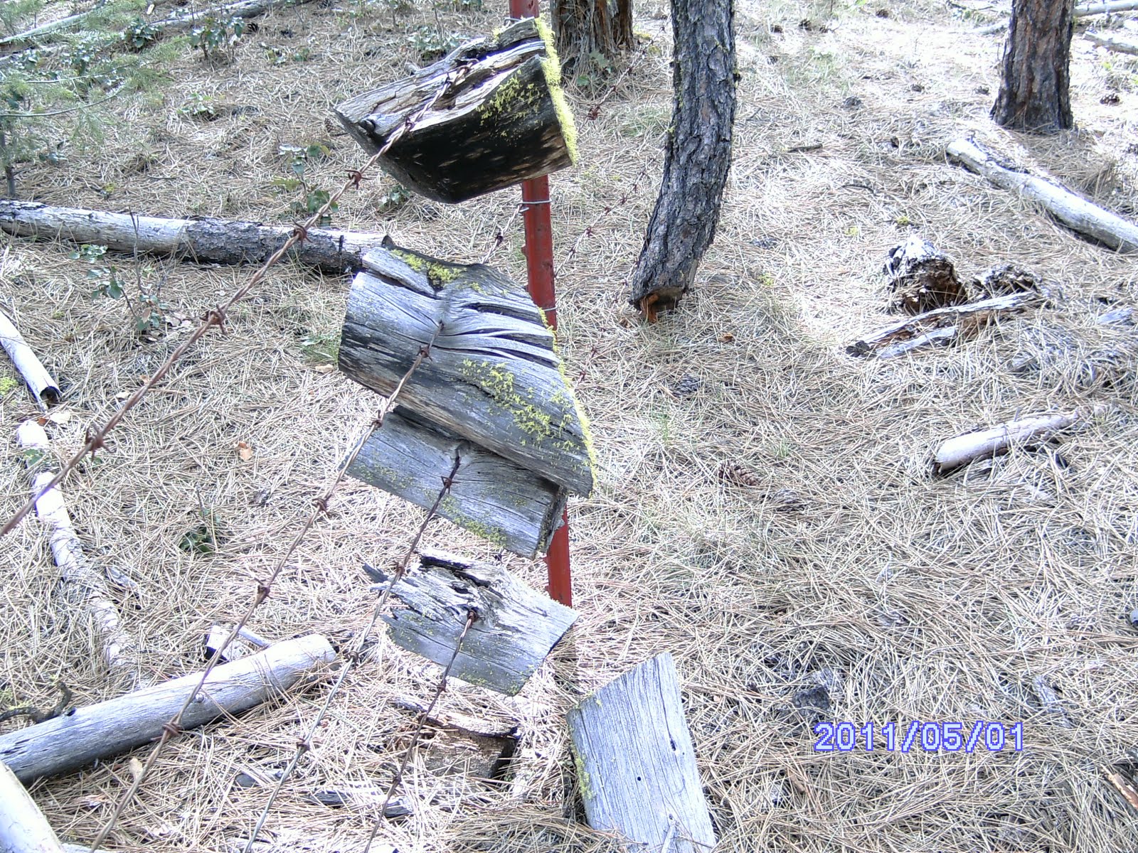
Interesting places where the fence had been built and rebuilt several times over probably the last 6-7 decades including many places such as the picture where trees had grown around the barb wire.


At about 11 miles in at mp 104 we started down towards the river and had to cross a steep canyon at a junction of two streams before they dropped off below.


Used a log to cross the side stream easier than the first one. I slipped off a rock and wet my socks in the first stream crossing. The views into the Klamath River canyon were beautiful, but we were running out of daylight and I started calling Paul.


I had good service and texted him we were looking at a 7PM show on the road below as we skirted to the west along the high canyon wall initially.


The grades were steep and we were encounter a little more brush and oaks at this point, so I later texted Paul it would be closer to 7:30 which he acknowledged.


Dwane struck a pose on the way down.


It was slow going along the steep hill side until we found a finger with a little less slope to start down. We could see Mt Ashland to the west as we descended into the canyon (1st Pic in this post at top).


PLAN C: Shortly after hitting the bottom of the canyon and Topsy Road right at 7:25PM Paul called us with bad news as we were resting our feet and contemplating having traveled 20+ miles to get credit for 15. Paul was blocked at the top of the Topsy Grade and couldn’t get past a large mud hole covering 75 yards of the roadway. We had a quick conference and determined we had no other choice but to walk to him. It was now sundown as we started up what we figured was a 3 plus mile hike up the historic road and side hill cut to the top of the canyon that we had just descended into with so much difficulty. We passed a herd of perhaps 20 deer in a meadow as darkness set in and we trudged on. Probably about 9:30 we passed through a side hill cut that is an engineering feat in and of itself as it was constructed in the 1880s. I can’t imagine wagons rolling up the grade and along the ledge and thru the side cut into a basalt rock cliff. We noted several abandoned cars that had been deposited over the cliff along the grade and remained wedged in trees a few hundred feet below the road bed before the light gave out. As we crested the top near a historic stage coach stop called the Topsy Site we oriented our selves at an intersection. To the south perhaps 2 miles was our car a half mile off the road into the woods, but Paul had said his vehicle GPS indicated he was only a short distance from the intersection- so we trudged on to the north in the dark. We had also failed to gas up as intended in the last town we’d gone through while doing all the shuttling, so we were concerned there wouldn’t be a station open when we went back through Doris, CA. After perhaps a mile or so in the dark and calling Paul to have him honk and flash his lights without being able to hear or see him, he conveyed some more bad news. His car GPS now couldn’t decide if he was 1 or 2 miles from the intersection. So, we likely could have just walked the same distance back to our car in the dark. Found him about 2 miles north on the road, loaded up, picked up a can of gas in K Falls, topped his mom’s Explore off, and headed back south on 97 to Doris and back up into the woods to retrieve our car. Managed to first make a wrong turn on the skid roads and waste a half hour, then try a short cut (My bad) and nearly get stuck in the mud before we found our car. We transferred our tired bodies and muddy clothes into the Saturn after adding a gallon of fuel to the tank and headed back to the motel in K Falls. Rolled into the room at 1:30 in the morning with a long tiring day planned next.